|
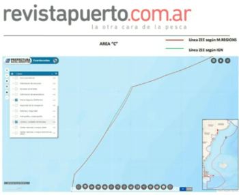
Image: Revista Puerto
Myths and realities of Mile 201
 ARGENTINA
Friday, April 14, 2023, 19:00 (GMT + 9)
The same problem at sea and two divergent limits in the Argentine Exclusive Economic Zone. The environmental complexity of fishing by foreign fleets at Mile 201 and the multiple actors and interests involved highlight the importance of verifying the veracity of the information received.
Information of hundreds of income from illegal ships, robberies and millionaire losses for our country are common currency in Argentina and the world. A good part of those who disseminate it do so based on a simple process of repetition, a kind of automatic copy and paste, for having heard or read it somewhere, without much verification through.
.jpg)
The reliability of the data is reinforced if they come from the work of international researchers under the auspices of a globally recognized organization. Why then not inquire about the sources of information used by these researchers before taking them for granted? Taking into account that surely and for obvious reasons, in general they do not obtain the information by direct observation at sea and instead use platforms satellite visualization of ships.
Some pioneers in the perspective applied to the use of these platforms, such as the Uruguayan journalist and researcher Sabina Goldaracena, realized a couple of years ago that in platforms of this type the limits of the Exclusive Economic Zones of Argentina and Uruguay present divergences with regarding the officials of each country.
.jpg)
In the Argentine case, those monitoring platforms that use as standard base mapping, names of places and marine areas georeferenced by Marine Regions, present considerable differences in their limits of the ZEEA with respect to the official limit in force in our country in sections other than the area in dispute with the United Kingdom around the Malvinas, Georgias and South Sandwich Islands.
Marine Regions is an integration of two large databases, one containing geographic names, mainly marine, and the other, maritime boundaries. In the combination of this information, the Exclusive Economic Zones (EEZ) of the world are represented, giving rise to information that we can see in the base maps of different platforms and other types of Geographic Information Systems available.
.jpg)
The evidence
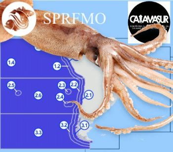
Through the use of the Coast Guard System of the Argentine Naval Prefecture, this divergence of limits between the current official and that of the Marine Regions could be translated into exact numbers. The latter expands the ZEEA in most of the approximately 900 kilometers of maritime border (beyond which is what we define as Mile 201, the High Seas area where the foreign distant-water fishing fleet operates).
This shift, as can be seen in the images that accompany this note, reaches its greatest expression at the height of the San Jorge Gulf (in the so-called Blue Hole), where maximum values of difference of up to 4.4 nautical miles (a little more than 8 kilometers). It corresponds to the area with the highest concentration of foreign and national vessels in search of Illex Squid and other important commercial straddling species in our country.
For its part, in the northern area of the outer limit of the ZEEA (at the height of the San Matías Gulf), where the fishing fleets in search of squid are concentrated as of March, this shift of the limit of Marine Regions to the east, it reaches values of up to 1.51 nautical miles (just under 3 kilometers).
.jpg)
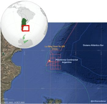
A platform with the ZEEA extended with respect to the official account erroneously reports illegal intrusions by foreign fishing vessels and other activities or conduct at sea, associating them with illegal actions.
The same Coast Guard System was used to measure the induced error, verifying the operation in the areas with differences between both limits during 2022, of more than 250 presumably "illegal" fishing vessels according to the limits used by Marine Regions, representing an example of the possible information and misinterpretation of activities and behaviors at sea, based on the use of unofficial limits.
Implications of this divergence
Given that there are very many organizations, universities, NGOs and researchers that use monitoring platforms with Marine Regions base mapping, it is worth considering the scope and implications of this incorrect demarcation.
From the alleged "illegal intrusions", estimates of losses or thefts to our country, of illegal transshipments, of fishing vessels that turn off their AIS to later carry out illegal fishing in Argentine waters and the belief that there is a situation of general lack of control of this maritime border.
.jpg)
Some of these platforms such as Marine Protection by Country, Fishing Area Finder and Global Fishing Watch -it is worth mentioning the latter makes a disclaimer regarding this mapping, allowing the user to raise their own limits-, have incorporated important satellite technology and artificial intelligence, Therefore, they are permanent employment tools for researchers and authorities.
Based on the finding of this divergence of limits, it would be good to wonder if the authors of numerous studies carried out based on the information from these platforms would have reached the same conclusions if they had based themselves on the correct limits.
We can conclude on the need to verify and be critical of the sources, whatever their origin. That the more misinformed we are, the more we move away from understanding the reality that affects us and the more difficult it will be to solve it.
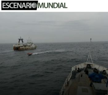
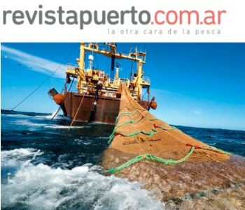
The problem surrounding the operation of this foreign fleet exists and is not the result of income to our EEZ or lack of control (although it can and should be improved), but rather is the product of more than 500 foreign fishing vessels operating for months no catch limits at Mile 201 on straddling and highly migratory species of the EEZ.
Author/Source: Lic. Sergio Almada/Revista Puerto (translated from original in spanish)

Graduate and Professor in Geography. Graduate in Maritime Safety. Diploma in policies for the sustainable future of the sea. Coordinator of the Interdisciplinary Team for the Control of Maritime Spaces (EICEMAR) of the Argentine Naval Prefecture. Professor of the Higher School of Marine Sciences of the National University of Comahue.
Related News:


.jpg)
.jpg)
.jpg)

.jpg)
[email protected]
www.seafood.media
|


.jpg)
 Print
Print